
Carte topographique Southern District
Carte interactive
Cliquez sur la carte pour afficher l’altitude.
À propos de cette carte
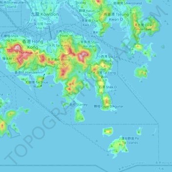
Nom : Carte topographique Southern District, altitude, relief.
Lieu : Southern District, Hong Kong Island, Hong Kong, 852, China (22.19265 114.11010 22.27561 114.30905)
Altitude moyenne : 36 m
Altitude minimum : -6 m
Altitude maximum : 532 m
Autres cartes topographiques
Cliquez sur une carte pour visualiser sa topographie, son altitude et son relief.
Sham Shui Po District
Sham Shui Po District, Kowloon, Hong Kong, China
Altitude moyenne : 58 m
Wan Chai District
Wan Chai District, Hong Kong Island, Hong Kong, China
Altitude moyenne : 122 m