
Carte topographique Limuru
Carte interactive
Cliquez sur la carte pour afficher l’altitude.
À propos de cette carte
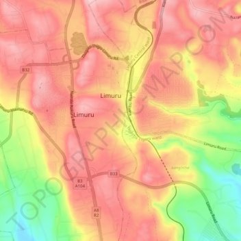
Nom : Carte topographique Limuru, altitude, relief.
Lieu : Limuru, Kiambu, Central Kenya, 00217, Kenya (-1.13824 36.61197 -1.10382 36.66160)
Altitude moyenne : 2 254 m
Altitude minimum : 2 132 m
Altitude maximum : 2 319 m
Most of the area of Limuru is now what was previously known as the "white highlands", a rich agricultural land south of the equator. The term "white highlands" derived from the British and other Europeans who realised the productive potential of this area and settled in large numbers with the support of the colonial government, establishing coffee and tea plantations, cereal farms and ranches. The altitude of the town is about 2,500 meters. Limuru has a temperature of 10–28 °C (75 °F) year round.
Autres cartes topographiques
Cliquez sur une carte pour visualiser sa topographie, son altitude et son relief.
Kabuku
Kenya > Kiambu > Limuru > Ngecha Tigoni ward
Kabuku, Ngecha Tigoni ward, Limuru, Kiambu, Central Kenya, Kenya
Altitude moyenne : 2 138 m
Limuru Central ward
Limuru Central ward, Limuru, Kiambu, Central Kenya, 00217, Kenya
Altitude moyenne : 2 219 m