
Faire un don
Équipez-vous pour votre prochaine aventure :
En tant que Partenaire Amazon, ce site perçoit une commission sur les achats éligibles sans surcoût pour vous.
Carte topographique Poorman Hill
Cliquez sur la carte pour afficher l’altitude.
Faire un don
Équipez-vous pour votre prochaine aventure :
En tant que Partenaire Amazon, ce site perçoit une commission sur les achats éligibles sans surcoût pour vous.
À propos de cette carte
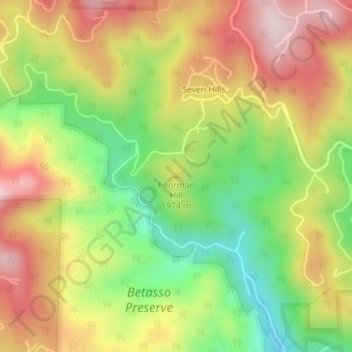
Nom : Carte topographique Poorman Hill, altitude, relief.
Lieu : Poorman Hill, Boulder County, Colorado, United States (40.03049 -105.33588 40.03059 -105.33578)
Altitude moyenne : 1 945 m
Altitude minimum : 1 756 m
Altitude maximum : 2 131 m
Faire un don
Équipez-vous pour votre prochaine aventure :
En tant que Partenaire Amazon, ce site perçoit une commission sur les achats éligibles sans surcoût pour vous.
Autres cartes topographiques
Cliquez sur une carte pour visualiser sa topographie, son altitude et son relief.
Nederland
United States > Colorado > Boulder County
In 1873 the Caribou Mine, at an elevation of roughly 10,000 feet (3,000 m) and 6 miles (10 km) northwest of the town, was sold to the Mining Company Nederland from the Netherlands. The high elevation meant fierce winds and deep winter snow, so the new owners of the mine decided that it was beneficial to bring…
Altitude moyenne : 2 578 m
University of Colorado Boulder (Williams Village)
United States > Colorado > Boulder County > Boulder
Altitude moyenne : 1 634 m
Fredrick Law Olmsted, Jr. Park
United States > Colorado > Boulder County > Boulder
Altitude moyenne : 1 664 m
Faire un don
Équipez-vous pour votre prochaine aventure :
En tant que Partenaire Amazon, ce site perçoit une commission sur les achats éligibles sans surcoût pour vous.
Jamestown
United States > Colorado > Boulder County
Jamestown is in central Boulder County at 40°6′56″N 105°23′15″W / 40.11556°N 105.38750°W / 40.11556; -105.38750 (40.115485, −105.387531). It lies along James Creek within the Front Range of the Colorado Rockies, with access via James Canyon Drive, which leads east 8 miles (13 km) to U.S.…
Altitude moyenne : 2 271 m
Faire un don
Équipez-vous pour votre prochaine aventure :
En tant que Partenaire Amazon, ce site perçoit une commission sur les achats éligibles sans surcoût pour vous.
National Center for Atmospheric Research
United States > Colorado > Boulder County > Boulder
Altitude moyenne : 1 816 m
Faire un don
Équipez-vous pour votre prochaine aventure :
En tant que Partenaire Amazon, ce site perçoit une commission sur les achats éligibles sans surcoût pour vous.