
Carte topographique Đà Nẵng
Carte interactive
Cliquez sur la carte pour afficher l’altitude.
Đà Nẵng
Geologically, Da Nang is at the edge of a Paleozoic fold belt known as the Truong Son Orogenic Zone, whose main deformation occurred during the early Carboniferous period. Da Nang's topography is dominated by the steep Annamite mountain range to the north and north-west, which features peaks ranging from 700 to 1,500 m (2,300 to 4,900 ft) in height, and low-lying coastal plains with some salting to the south and east, with several white sand beaches along the coast.
À propos de cette carte
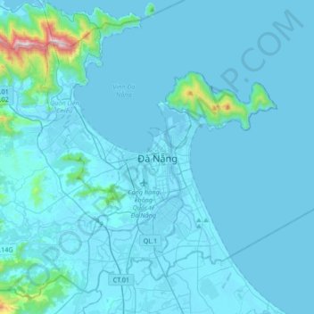
Nom : Carte topographique Đà Nẵng, altitude, relief.
Lieu : Đà Nẵng, Da Nang, 236, Vietnam (15.90800 108.05200 16.22800 108.37200)
Altitude moyenne : 52 m
Altitude minimum : -2 m
Altitude maximum : 1 143 m