
Carte topographique Markham
Carte interactive
Cliquez sur la carte pour afficher l’altitude.
À propos de cette carte
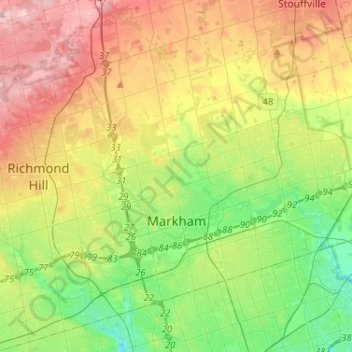
Nom : Carte topographique Markham, altitude, relief.
Lieu : Markham, York Region, Golden Horseshoe, Ontario, Canada (43.79804 -79.42873 43.96251 -79.17024)
Altitude moyenne : 216 m
Altitude minimum : 135 m
Altitude maximum : 333 m
Markham's average altitude is at 200 m (660 ft) and in general consists of gently rolling hills. The city is intersected by two rivers; the Don River and Rouge River, as well as their tributaries. To the north is the Oak Ridges Moraine, which further elevates the elevation towards the north.