
Carte topographique Thôn 8
Carte interactive
Cliquez sur la carte pour afficher l’altitude.
À propos de cette carte
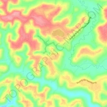
Nom : Carte topographique Thôn 8, altitude, relief.
Lieu : Thôn 8, Đắk Song District, Đắk Nông Province, Vietnam (12.17964 107.55714 12.21964 107.59714)
Altitude moyenne : 820 m
Altitude minimum : 769 m
Altitude maximum : 869 m
Autres cartes topographiques
Cliquez sur une carte pour visualiser sa topographie, son altitude et son relief.
Đức An
Vietnam > Đắk Nông Province > Đắk Song District > Đức An
Đức An, Đắk Song District, Đắk Nông Province, Vietnam
Altitude moyenne : 857 m