
Carte topographique Pretoria
Carte interactive
Cliquez sur la carte pour afficher l’altitude.
À propos de cette carte
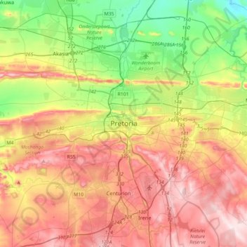
Nom : Carte topographique Pretoria, altitude, relief.
Altitude moyenne : 1 363 m
Altitude minimum : 1 151 m
Altitude maximum : 1 599 m
Pretoria is situated approximately 56 km (35 mi) north-northeast of Johannesburg in the northeast of South Africa, in a transitional belt between the plateau of the Highveld to the south and the lower-lying Bushveld to the north. It lies at an altitude of about 1,339 m (4,393 ft) above sea level, in a warm, sheltered, fertile valley, surrounded by the hills of the Magaliesberg range.