
Carte topographique Chitral
Carte interactive
Cliquez sur la carte pour afficher l’altitude.
À propos de cette carte
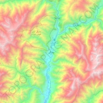
Nom : Carte topographique Chitral, altitude, relief.
Altitude moyenne : 2 982 m
Altitude minimum : 1 358 m
Altitude maximum : 5 126 m
The city has an average elevation of 1,500 m (4,921 ft).
Autres cartes topographiques
Cliquez sur une carte pour visualiser sa topographie, son altitude et son relief.
Mastuj Tehsil
Pakistan > Khyber Pakhtunkhwa > Chitrāl District
Mastuj Tehsil, Upper Chitral District, Chitrāl District, Malakand Division, Khyber Pakhtunkhwa, Pakistan
Altitude moyenne : 4 143 m
Buni Zom
Pakistan > Khyber Pakhtunkhwa > Chitrāl District > Mastuj Tehsil
Buni Zom, Mastuj Tehsil, Upper Chitral District, Chitrāl District, Malakand Division, Khyber Pakhtunkhwa, Pakistan
Altitude moyenne : 5 757 m
Drosh Tehsil
Pakistan > Khyber Pakhtunkhwa > Chitrāl District
Drosh Tehsil, Lower Chitral District, Chitrāl District, Malakand Division, Khyber Pakhtunkhwa, 17220, Pakistan
Altitude moyenne : 3 012 m
Koyo Zom
Pakistan > Khyber Pakhtunkhwa > Chitrāl District
Koyo Zom, Upper Chitral District, Chitrāl District, Malakand Division, Khyber Pakhtunkhwa, Pakistan
Altitude moyenne : 5 925 m
Gree
Pakistan > Khyber Pakhtunkhwa > Chitrāl District > Chitral Tehsil
Gree, Chitral Tehsil, Lower Chitral District, Chitrāl District, Malakand Division, Khyber Pakhtunkhwa, Pakistan
Altitude moyenne : 2 883 m
Hindu Kush
Pakistan > Khyber Pakhtunkhwa > Chitrāl District > Chitral Tehsil
Hindu Kush, Chitral Tehsil, Lower Chitral District, Chitrāl District, Malakand Division, Khyber Pakhtunkhwa, Pakistan
Altitude moyenne : 5 281 m