
Carte topographique Esrange Space Center
Carte interactive
Cliquez sur la carte pour afficher l’altitude.
À propos de cette carte
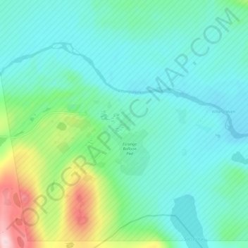
Nom : Carte topographique Esrange Space Center, altitude, relief.
Altitude moyenne : 332 m
Altitude minimum : 278 m
Altitude maximum : 528 m
Esrange Space Center (short form Esrange) is a rocket range and research centre located about 40 kilometers east of the town of Kiruna in northern Sweden. It is a base for scientific research with high-altitude balloons, investigation of the aurora borealis, sounding rocket launches, and satellite tracking, among other things. Located 200 km north of the Arctic Circle and surrounded by a vast wilderness, its geographic location is ideal for many of these purposes.