
Carte topographique Vinh
Carte interactive
Cliquez sur la carte pour afficher l’altitude.
À propos de cette carte
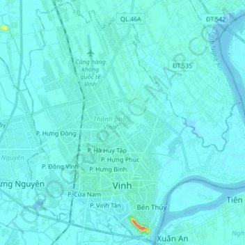
Nom : Carte topographique Vinh, altitude, relief.
Lieu : Vinh, Nghệ An Province, Vietnam (18.63932 105.63365 18.76521 105.76896)
Altitude moyenne : 5 m
Altitude minimum : -1 m
Altitude maximum : 88 m
Autres cartes topographiques
Cliquez sur une carte pour visualiser sa topographie, son altitude et son relief.
Bản Lốc
Vietnam > Nghe An province > Quế Phong District
Bản Lốc, Quế Phong District, Nghệ An Province, Vietnam
Altitude moyenne : 336 m
Diễn Châu District
Diễn Châu District, Nghệ An Province, Vietnam
Altitude moyenne : 24 m
Nghi Lộc District
Vietnam > Nghe An province > Nghi Lộc District
Nghi Lộc District, Nghe An province, 460000, Vietnam
Altitude moyenne : 32 m
Tân Lập
Vietnam > Nghe An province > Tân Lập
Tân Lập, Tân Kỳ District, Nghe An province, Vietnam
Altitude moyenne : 83 m