
Carte topographique Central Hawke's Bay District
Carte interactive
Cliquez sur la carte pour afficher l’altitude.
À propos de cette carte
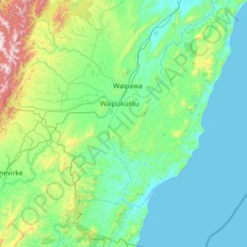
Nom : Carte topographique Central Hawke's Bay District, altitude, relief.
Lieu : Central Hawke's Bay District, Hawke's Bay, New Zealand (-40.43129 176.09383 -39.68006 176.96769)
Altitude moyenne : 236 m
Altitude minimum : -1 m
Altitude maximum : 1 718 m
Autres cartes topographiques
Cliquez sur une carte pour visualiser sa topographie, son altitude et son relief.
Sherenden
New Zealand > Hawke's Bay > Hastings District
Sherenden, Hastings District, Hawke's Bay, New Zealand
Altitude moyenne : 258 m
Waipukurau
New Zealand > Hawke's Bay > Central Hawke's Bay District
Waipukurau, Central Hawke's Bay District, Hawke's Bay, 4200, New Zealand
Altitude moyenne : 153 m
Hastings District
Hastings District, Hawke's Bay, New Zealand
Altitude moyenne : 466 m
Hastings
New Zealand > Hawke's Bay > Hastings District
Hastings, Hastings District, Hawke's Bay, 4122, New Zealand
Altitude moyenne : 68 m
Te Awanga
New Zealand > Hawke's Bay > Hastings District
Te Awanga, Hastings District, Hawke's Bay, 4180, New Zealand
Altitude moyenne : 22 m
Cape Kidnappers / Te Kauwae-a-Māui
New Zealand > Hawke's Bay > Hastings District
Cape Kidnappers / Te Kauwae-a-Māui, Hastings District, Hawke's Bay, New Zealand
Altitude moyenne : 16 m
Pakipaki
New Zealand > Hawke's Bay > Hastings District > Hastings
Pakipaki, Hastings, Hastings District, Hawke's Bay, 4178, New Zealand
Altitude moyenne : 61 m