
Carte topographique Sauble
Carte interactive
Cliquez sur la carte pour afficher l’altitude.
À propos de cette carte
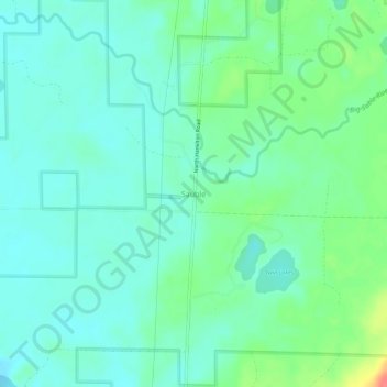
Nom : Carte topographique Sauble, altitude, relief.
Altitude moyenne : 227 m
Altitude minimum : 212 m
Altitude maximum : 271 m
Autres cartes topographiques
Cliquez sur une carte pour visualiser sa topographie, son altitude et son relief.
Irons
United States > Michigan > Lake County
Irons, Eden Township, Lake County, Michigan, 49644, United States
Altitude moyenne : 263 m
Peacock
United States > Michigan > Lake County
Peacock, Peacock Township, Lake County, Michigan, United States
Altitude moyenne : 275 m
Sunshine Lake
United States > Michigan > Lake County
Sunshine Lake, Elk Township, Lake County, Michigan, United States
Altitude moyenne : 238 m
Lake Township
United States > Michigan > Lake County
Lake Township, Lake County, Michigan, 49394, United States
Altitude moyenne : 253 m
Yates Township
United States > Michigan > Lake County
Yates Township, Lake County, Michigan, 49642, United States
Altitude moyenne : 286 m