
Carte topographique Holly Hill
Carte interactive
Cliquez sur la carte pour afficher l’altitude.
À propos de cette carte
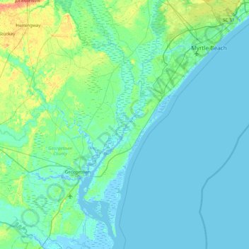
Nom : Carte topographique Holly Hill, altitude, relief.
Lieu : Holly Hill, Georgetown County, South Carolina, 29585, USA (33.17739 -79.46949 33.81739 -78.82949)
Altitude moyenne : 5 m
Altitude minimum : -4 m
Altitude maximum : 30 m
Autres cartes topographiques
Cliquez sur une carte pour visualiser sa topographie, son altitude et son relief.
Kiawah Island Bass Pond D-3047 Dam
USA > South Carolina > Kiawah Island
Kiawah Island Bass Pond D-3047 Dam, Kiawah Island, Charleston County, South Carolina, USA
Altitude moyenne : 1 m
Saint Helena Island
Saint Helena Island, Beaufort County, South Carolina, 29920, USA
Altitude moyenne : 2 m
Pelion
USA > South Carolina > Pelion
Pelion, Lexington County, South Carolina, 29123, USA
Altitude moyenne : 127 m
Congaree National Park
USA > South Carolina > Totness
Congaree National Park, Hedrick Lane, Totness, Calhoun County, South Carolina, USA
Altitude moyenne : 55 m
Georgetown
USA > South Carolina > Georgetown
Georgetown, Georgetown County, South Carolina, USA
Altitude moyenne : 2 m
Spring Acres
USA > South Carolina > Spring Acres
Spring Acres, Darlington County, South Carolina, 29532, USA
Altitude moyenne : 46 m
Seven Oaks
USA > South Carolina > Seven Oaks
Seven Oaks, Lexington County, South Carolina, USA
Altitude moyenne : 78 m
Palmetto Fort
USA > South Carolina > Palmetto Fort
Palmetto Fort, Charleston County, South Carolina, 29466, USA
Altitude moyenne : 4 m
Dillon
USA > South Carolina > Dillon
Dillon, Dillon County, South Carolina, 29536, USA
Altitude moyenne : 35 m
Jason
USA > South Carolina > Jason
Jason, Oconee County, South Carolina, 29643:29678:29691:29693:29696, USA
Altitude moyenne : 269 m
Pine Creek
USA > South Carolina > Pine Creek
Pine Creek, Kershaw County, South Carolina, 29020, USA
Altitude moyenne : 73 m
Cane Savannah
USA > South Carolina > Cane Savannah
Cane Savannah, Sumter County, South Carolina, 29154, USA
Altitude moyenne : 54 m
Grenadier
USA > South Carolina > Grenadier
Grenadier, Lexington County, South Carolina, 29210, USA
Altitude moyenne : 74 m
Cape Romain National Wildlife Refuge
USA > South Carolina > Awendaw
Cape Romain National Wildlife Refuge, Awendaw, Charleston County, South Carolina, USA
Altitude moyenne : 3 m
Sullivans Island
USA > South Carolina > Sullivans Island
Sullivans Island, Charleston County, South Carolina, 29482, USA
Altitude moyenne : 1 m
Plum Island
USA > South Carolina > Charleston
Plum Island, Charleston, Charleston County, South Carolina, 29402, USA
Altitude moyenne : 3 m
Sheepbridge Branch
Sheepbridge Branch, Horry County, South Carolina, USA
Altitude moyenne : 12 m
Tenmile
USA > South Carolina > Tenmile
Tenmile, Charleston County, South Carolina, 29416, USA
Altitude moyenne : 9 m
Simmonsville
USA > South Carolina > Simmonsville
Simmonsville, Georgetown County, South Carolina, USA
Altitude moyenne : 5 m