
Carte topographique District of Košice I
Carte interactive
Cliquez sur la carte pour afficher l’altitude.
À propos de cette carte
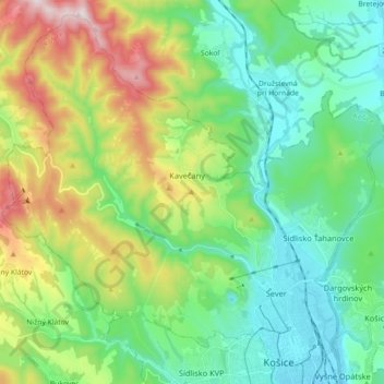
Nom : Carte topographique District of Košice I, altitude, relief.
Altitude moyenne : 390 m
Altitude minimum : 202 m
Altitude maximum : 836 m
Autres cartes topographiques
Cliquez sur une carte pour visualiser sa topographie, son altitude et son relief.
Hornád
Slovakia > Region of Košice > Košice
Hornád, Priemyselná, Stredné Mesto, Košice - mestská časť Staré Mesto, Košice, Region of Košice, Eastern Slovakia, 04291, Slovakia
Altitude moyenne : 232 m