Géolocaliser

Carte topographique Estry

Cliquez sur la carte pour afficher l’altitude.

À propos de cette carte

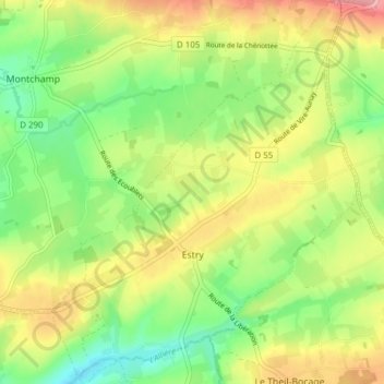
Nom : Carte topographique Estry, altitude, relief.

Lieu : Estry, Valdallière, Vire, Calvados, Normandie, France métropolitaine, 14410, France (48.88009 -0.76307 48.93052 -0.70143)

Altitude moyenne : 194 m

Altitude minimum : 142 m

Altitude maximum : 259 m

Autres cartes topographiques

Cliquez sur une carte pour visualiser sa topographie, son altitude et son relief.

La Lamerie

France > Normandie > Calvados > Valdallière

Altitude moyenne : 218 m

La Croix Verte

France > Normandie > Calvados > Valdallière

Altitude moyenne : 188 m

Le Douit

France > Normandie > Calvados > Valdallière

Altitude moyenne : 183 m

Le Petit Cagny

France > Normandie > Calvados > Valdallière

Altitude moyenne : 151 m

Fréval

France > Normandie > Calvados > Valdallière

Altitude moyenne : 180 m

La Mazure

France > Normandie > Calvados > Valdallière

Altitude moyenne : 219 m

La Cosnerie

France > Normandie > Calvados > Valdallière

Altitude moyenne : 148 m

Noron

France > Normandie > Calvados > Valdallière

Altitude moyenne : 216 m

Équipez-vous pour votre prochaine aventure :

🚲Support smartphone pour vélo - Utilisez topographic-map.com en direct sur votre guidon
🧤Gants thermiques outdoor - Gants pour conditions froides en extérieur
🧥Doudounes outdoor - Chaleur et légèreté en conditions froides
🛏️Matelas de sol - Isolation et confort pour dormir en plein air
❄️Crampons antidérapants - Adhérence sur neige et glace

En tant que Partenaire Amazon, ce site perçoit une commission sur les achats éligibles sans surcoût pour vous.