
Faire un don
Équipez-vous pour votre prochaine aventure :
En tant que Partenaire Amazon, ce site perçoit une commission sur les achats éligibles sans surcoût pour vous.
Carte topographique Windsor
Cliquez sur la carte pour afficher l’altitude.
Faire un don
Équipez-vous pour votre prochaine aventure :
En tant que Partenaire Amazon, ce site perçoit une commission sur les achats éligibles sans surcoût pour vous.
Windsor
Some days in the winter and spring can be warm and extremely dry, with Chinook winds often raising temperatures to near 70 °F (21 °C) in January and February, and sometimes to near 90 °F (32 °C) in April. Windsor's elevation and low year-round humidity means that nighttime low temperatures are practically never above 68 °F (20 °C), even in the very hottest part of the summer. The diurnal temperature range is usually rather wide, with a 50-degree (Fahrenheit) difference between daytime high and nighttime low not uncommon, especially in the spring and fall months. Rapid fluctuation in temperature is also common – a sunny 80 °F (27 °C) October afternoon can easily give way to a 28 °F (-2 °C) blizzard within 12 hours.
Faire un don
Équipez-vous pour votre prochaine aventure :
En tant que Partenaire Amazon, ce site perçoit une commission sur les achats éligibles sans surcoût pour vous.
À propos de cette carte
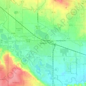
Nom : Carte topographique Windsor, altitude, relief.
Lieu : Windsor, Weld County, Colorado, 80550-5129, United States (40.43748 -104.94136 40.51748 -104.86136)
Altitude moyenne : 1 471 m
Altitude minimum : 1 441 m
Altitude maximum : 1 527 m
Faire un don
Équipez-vous pour votre prochaine aventure :
En tant que Partenaire Amazon, ce site perçoit une commission sur les achats éligibles sans surcoût pour vous.