
Carte topographique Hentland
Carte interactive
Cliquez sur la carte pour afficher l’altitude.
À propos de cette carte
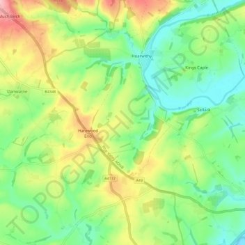
Nom : Carte topographique Hentland, altitude, relief.
Lieu : Hentland, Harewood End, Herefordshire, England, United Kingdom (51.90719 -2.69395 51.97594 -2.64377)
Altitude moyenne : 85 m
Altitude minimum : 29 m
Altitude maximum : 177 m
Autres cartes topographiques
Cliquez sur une carte pour visualiser sa topographie, son altitude et son relief.
Michaelchurch
United Kingdom > England > Herefordshire > Harewood End
Michaelchurch, Tretire with Michaelchurch, Harewood End, Herefordshire, England, HR2 8LD, United Kingdom
Altitude moyenne : 90 m