
Faire un don
Équipez-vous pour votre prochaine aventure :
En tant que Partenaire Amazon, ce site perçoit une commission sur les achats éligibles sans surcoût pour vous.
Carte topographique Mammoth Lakes
Cliquez sur la carte pour afficher l’altitude.
Faire un don
Équipez-vous pour votre prochaine aventure :
En tant que Partenaire Amazon, ce site perçoit une commission sur les achats éligibles sans surcoût pour vous.
Mammoth Lakes
Mammoth Lakes is a town in Mono County, California, the county's only incorporated community. It is located immediately to the east of Mammoth Mountain, at an elevation of 7,880 feet (2,400 m). As of the 2010 United States Census, the population was 8,234, reflecting a 16% increase from the 2000 Census.
Faire un don
Équipez-vous pour votre prochaine aventure :
En tant que Partenaire Amazon, ce site perçoit une commission sur les achats éligibles sans surcoût pour vous.
À propos de cette carte
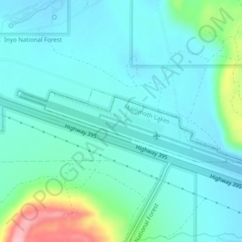
Nom : Carte topographique Mammoth Lakes, altitude, relief.
Lieu : Mammoth Lakes, Mono County, California, United States (37.62303 -118.86232 37.63121 -118.83448)
Altitude moyenne : 2 184 m
Altitude minimum : 2 154 m
Altitude maximum : 2 312 m
Faire un don
Équipez-vous pour votre prochaine aventure :
En tant que Partenaire Amazon, ce site perçoit une commission sur les achats éligibles sans surcoût pour vous.