
Carte topographique Disaneng Dam
Carte interactive
Cliquez sur la carte pour afficher l’altitude.
À propos de cette carte
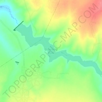
Nom : Carte topographique Disaneng Dam, altitude, relief.
Altitude moyenne : 1 202 m
Altitude minimum : 1 175 m
Altitude maximum : 1 240 m
Autres cartes topographiques
Cliquez sur une carte pour visualiser sa topographie, son altitude et son relief.
Mahikeng Ward 21
RSA > North West > Mahikeng Local Municipality
Mahikeng Ward 21, Mahikeng Local Municipality, Ngaka Modiri Molema District Municipality, North West, RSA
Altitude moyenne : 1 308 m
Mafikeng Game Reserve
RSA > North West > Mahikeng Local Municipality
Mafikeng Game Reserve, R503, Ditsobotla Ward 10, Mahikeng Local Municipality, Ngaka Modiri Molema District Municipality, North West, RSA
Altitude moyenne : 1 334 m
Mareetsane
RSA > North West > Mahikeng Local Municipality
Mareetsane, Mahikeng Local Municipality, Ngaka Modiri Molema District Municipality, North West, RSA
Altitude moyenne : 1 330 m