
Carte topographique Doublet Peak
Carte interactive
Cliquez sur la carte pour afficher l’altitude.
À propos de cette carte
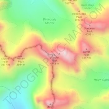
Nom : Carte topographique Doublet Peak, altitude, relief.
Lieu : Doublet Peak, Fremont County, Wyoming, USA (43.16323 -109.62964 43.16333 -109.62954)
Altitude moyenne : 3 738 m
Altitude minimum : 3 335 m
Altitude maximum : 4 177 m
Autres cartes topographiques
Cliquez sur une carte pour visualiser sa topographie, son altitude et son relief.
DuNoir Glacier
DuNoir Glacier, East Dunoir Trail, Fremont County, Wyoming, USA
Altitude moyenne : 3 236 m
Hooker Glacier
Hooker Glacier, Baptiste Lake, Fremont County, Wyoming, USA
Altitude moyenne : 3 420 m
Grand Teton National Park
Grand Teton National Park, Teton Park Road, Teton County, Wyoming, 83013, USA
Altitude moyenne : 2 409 m
Lower Fremont Glacier
Lower Fremont Glacier, Indain Pass Trail, Sublette County, Wyoming, USA
Altitude moyenne : 3 706 m
Cirque of the Towers
Cirque of the Towers, Fremont County, Wyoming, USA
Altitude moyenne : 3 347 m
Helen Glacier
Helen Glacier, Titcomb Basin Trail, Sublette County, Wyoming, USA
Altitude moyenne : 3 702 m
Yellowstone National Park
Yellowstone National Park, Mary Mountain-Nez Perce, Teton County, Wyoming, USA
Altitude moyenne : 2 450 m
Mount Woodrow Wilson
Mount Woodrow Wilson, Sublette County, Wyoming, USA
Altitude moyenne : 3 710 m
Gooseneck Glacier
Gooseneck Glacier, Glacier Trail, Fremont County, Wyoming, USA
Altitude moyenne : 3 701 m
Skillet Glacier
Skillet Glacier, Trapper Lake Trail, Teton County, Wyoming, USA
Altitude moyenne : 2 959 m
Twins Glacier
Twins Glacier, Titcomb Basin Trail, Sublette County, Wyoming, USA
Altitude moyenne : 3 599 m
Petersen Glacier
Petersen Glacier, Lake Solitude Trail, Teton County, Wyoming, USA
Altitude moyenne : 2 962 m
Continental Glacier
Continental Glacier, Fremont County, Wyoming, USA
Altitude moyenne : 3 768 m
Teepe Glacier
USA > Wyoming > Beaver Creek
Teepe Glacier, Garnet Canyon Trail, Beaver Creek, Teton County, Wyoming, USA
Altitude moyenne : 3 338 m
Heap Steep Glacier
Heap Steep Glacier, Glacier Trail, Fremont County, Wyoming, USA
Altitude moyenne : 3 698 m
Triple Glaciers
Triple Glaciers, Paintbrush Canyon, Teton County, Wyoming, USA
Altitude moyenne : 3 139 m
Minor Glacier
Minor Glacier, Glacier Trail, Sublette County, Wyoming, USA
Altitude moyenne : 3 678 m
Black Tooth Mountain
Black Tooth Mountain, Johnson County, Wyoming, USA
Altitude moyenne : 3 511 m
Falling Ice Glacier
Falling Ice Glacier, Paintbrush Canyon, Teton County, Wyoming, USA
Altitude moyenne : 2 988 m
Upper Fremont Glacier
Upper Fremont Glacier, Titcomb Basin Trail, Sublette County, Wyoming, USA
Altitude moyenne : 3 755 m
Stroud Glacier
Stroud Glacier, Glacier Trail, Sublette County, Wyoming, USA
Altitude moyenne : 3 529 m
Schoolroom Glacier
Schoolroom Glacier, Cascade Canyon Trail, Alta, Teton County, Wyoming, USA
Altitude moyenne : 3 065 m
Mammoth Glacier
Mammoth Glacier, Glacier Trail, Sublette County, Wyoming, USA
Altitude moyenne : 3 683 m
Harrower Glacier
Harrower Glacier, Indain Pass Trail, Sublette County, Wyoming, USA
Altitude moyenne : 3 637 m
Tiny Glacier
Tiny Glacier, Cook Lake Loop, Sublette County, Wyoming, USA
Altitude moyenne : 3 539 m
Middle Teton Glacier
USA > Wyoming > Beaver Creek
Middle Teton Glacier, Garnet Canyon Trail, Beaver Creek, Teton County, Wyoming, USA
Altitude moyenne : 3 383 m
Dinwoody Glacier
Dinwoody Glacier, Glacier Trail, Fremont County, Wyoming, USA
Altitude moyenne : 3 688 m
Teton Glacier
USA > Wyoming > Beaver Creek
Teton Glacier, Garnet Canyon Trail, Beaver Creek, Teton County, Wyoming, USA
Altitude moyenne : 3 307 m