
Carte topographique Selangor River
Carte interactive
Cliquez sur la carte pour afficher l’altitude.
À propos de cette carte
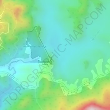
Nom : Carte topographique Selangor River, altitude, relief.
Altitude moyenne : 227 m
Altitude minimum : 103 m
Altitude maximum : 547 m
Autres cartes topographiques
Cliquez sur une carte pour visualiser sa topographie, son altitude et son relief.
Batu Pahat Hill
Malaysia > Selangor > Kuala Kubu Bharu
Batu Pahat Hill, Kuala Kubu Bharu, Hulu Selangor, Selangor, Malaysia
Altitude moyenne : 154 m
Sungai Chiling
Malaysia > Selangor > Kuala Kubu Bharu
Sungai Chiling, Kuala Kubu Bharu, Hulu Selangor, Selangor, Malaysia
Altitude moyenne : 444 m
Sungai Rening
Malaysia > Selangor > Kuala Kubu Bharu
Sungai Rening, Kuala Kubu Bharu, Hulu Selangor, Selangor, Malaysia
Altitude moyenne : 224 m
Bukit Kutu
Malaysia > Selangor > Kuala Kubu Bharu
Bukit Kutu, Kuala Kubu Bharu, Hulu Selangor, Selangor, Malaysia
Altitude moyenne : 759 m