
Carte topographique Ly Son
Carte interactive
Cliquez sur la carte pour afficher l’altitude.
À propos de cette carte
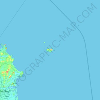
Nom : Carte topographique Ly Son, altitude, relief.
Lieu : Ly Son, Lý Sơn District, Quang Ngai province, Vietnam (15.06204 108.79900 15.70204 109.43900)
Altitude moyenne : 1 m
Altitude minimum : -2 m
Altitude maximum : 146 m
Autres cartes topographiques
Cliquez sur une carte pour visualiser sa topographie, son altitude et son relief.
Lý Sơn District
Lý Sơn District, Quảng Ngãi Province, 54400, Vietnam
Altitude moyenne : 5 m
La Vân
Vietnam > Quang Ngai province > Đức Phổ > La Vân
La Vân, Đức Phổ, Quang Ngai province, Vietnam
Altitude moyenne : 78 m
Long Thanh
Vietnam > Quang Ngai province > Đức Phổ > Long Thanh
Long Thanh, Đức Phổ, Quang Ngai province, Vietnam
Altitude moyenne : 20 m
Lý Sơn
Vietnam > Quang Ngai province > Lý Sơn
Lý Sơn, Quang Ngai province, Ly Son, 54400, Vietnam
Altitude moyenne : 14 m
Sơn Tây District
Vietnam > Quang Ngai province > Sơn Tây District
Sơn Tây District, Quang Ngai province, Vietnam
Altitude moyenne : 627 m
Lý Sơn District
Lý Sơn District, Quang Ngai province, Vietnam
Altitude moyenne : 10 m
Quảng Ngãi City
Quảng Ngãi City, Quảng Ngãi Province, Vietnam
Altitude moyenne : 14 m