
Faire un don
Équipez-vous pour votre prochaine aventure :
En tant que Partenaire Amazon, ce site perçoit une commission sur les achats éligibles sans surcoût pour vous.
Carte topographique Redwood National Park
Cliquez sur la carte pour afficher l’altitude.
Faire un don
Équipez-vous pour votre prochaine aventure :
En tant que Partenaire Amazon, ce site perçoit une commission sur les achats éligibles sans surcoût pour vous.
Redwood National Park
Redwoods prefer sheltered slopes, and they thrive on moist flat ground along rivers below 1,000 feet (300 m) in elevation. Coastal fog provides about 40 percent of their annual water intake. Redwoods have existed along the coast of northern California for at least 20 million years and are related to tree species that existed 160 million years ago in the Jurassic era. About 96 percent of the world's old-growth coast redwood forest has been logged, and almost half (45 percent) of what remains is in the RNSP. The parks protect 38,982 acres (157.75 km2) of old-growth forest, almost equally divided between federal and state management. The International Union for Conservation of Nature named the coast redwood an endangered species in 2011.
Faire un don
Équipez-vous pour votre prochaine aventure :
En tant que Partenaire Amazon, ce site perçoit une commission sur les achats éligibles sans surcoût pour vous.
À propos de cette carte
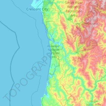
Nom : Carte topographique Redwood National Park, altitude, relief.
Altitude moyenne : 367 m
Altitude minimum : -4 m
Altitude maximum : 1 866 m
Faire un don
Équipez-vous pour votre prochaine aventure :
En tant que Partenaire Amazon, ce site perçoit une commission sur les achats éligibles sans surcoût pour vous.
Autres cartes topographiques
Cliquez sur une carte pour visualiser sa topographie, son altitude et son relief.
Crescent City
United States > California > Del Norte County
The topography of the sea floor surrounding Crescent City has the effect of focusing tsunamis. According to researchers at Humboldt State University and the University of Southern California, the city experienced tsunami conditions 31 times between the years 1933 and 2008. Although many of these incidents were…
Altitude moyenne : 31 m
Hiouchi
United States > California > Del Norte County
Hiouchi (Tolowa: Xaa-yuu-chit) is a census-designated place in Del Norte County, California. It is located on the Smith River 7.5 miles (12 km) east-northeast of Crescent City, at an elevation of 171 feet (52 m). Its population is 314 as of the 2020 census, up from 301 from the 2010 census.
Altitude moyenne : 162 m
Faire un don
Équipez-vous pour votre prochaine aventure :
En tant que Partenaire Amazon, ce site perçoit une commission sur les achats éligibles sans surcoût pour vous.
Crescent City
United States > California > Del Norte County
The topography of the sea floor surrounding Crescent City has the effect of focusing tsunamis. According to researchers at Humboldt State University and the University of Southern California, the city experienced tsunami conditions 31 times between the years 1933 and 2008.[25] Although many of these incidents…
Altitude moyenne : 6 m