
Carte topographique Town of Dryden
Carte interactive
Cliquez sur la carte pour afficher l’altitude.
À propos de cette carte
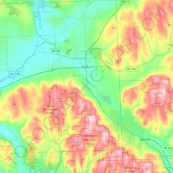
Nom : Carte topographique Town of Dryden, altitude, relief.
Lieu : Town of Dryden, Tompkins County, New York, United States (42.39623 -76.45407 42.55049 -76.25400)
Altitude moyenne : 430 m
Altitude minimum : 302 m
Altitude maximum : 619 m
Autres cartes topographiques
Cliquez sur une carte pour visualiser sa topographie, son altitude et son relief.
Village of Trumansburg
United States > New York > Tompkins County
Village of Trumansburg, Town of Ulysses, Tompkins County, New York, 14854, United States
Altitude moyenne : 300 m
Town of Danby
United States > New York > Tompkins County
Town of Danby, Tompkins County, New York, United States
Altitude moyenne : 404 m
City of Ithaca
United States > New York > Tompkins County
City of Ithaca, Tompkins County, New York, United States
Altitude moyenne : 195 m
Town of Newfield
United States > New York > Tompkins County
Town of Newfield, Tompkins County, New York, 14867, United States
Altitude moyenne : 426 m
Buttermilk Falls State Park
United States > New York > Tompkins County > Ithaca > Town of Danby
Buttermilk Falls State Park, Ithaca, Town of Danby, Tompkins County, New York, United States
Altitude moyenne : 269 m
East Ithaca
United States > New York > Tompkins County > Ithaca > East Ithaca
East Ithaca, Ithaca, Tompkins County, New York, United States
Altitude moyenne : 281 m
Town of Ithaca
United States > New York > Tompkins County
Town of Ithaca, Tompkins County, New York, United States
Altitude moyenne : 288 m
Waterburg
United States > New York > Tompkins County > Waterburg
Waterburg, Ulysses Town, Tompkins County, New York, 14886, United States
Altitude moyenne : 318 m