
Carte topographique Montevideo
Carte interactive
Cliquez sur la carte pour afficher l’altitude.
À propos de cette carte
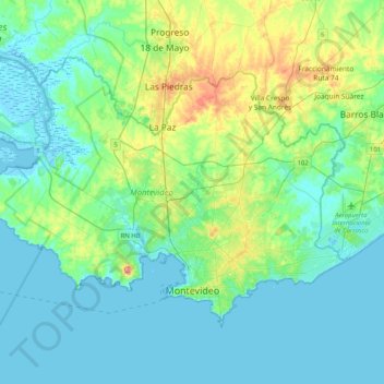
Nom : Carte topographique Montevideo, altitude, relief.
Lieu : Montevideo, Uruguay (-34.93806 -56.43140 -34.70185 -56.02250)
Altitude moyenne : 23 m
Altitude minimum : -4 m
Altitude maximum : 117 m
Between 1680 and 1683, Portugal founded the city of Colonia do Sacramento in the region across the bay from Buenos Aires. This city met with no resistance from the Spanish until 1723, when they began to place fortifications on the elevations around Montevideo Bay. On 22 November 1723, Field Marshal Manuel de Freitas da Fonseca of Portugal built the Montevieu fort.