
Carte topographique Camberwell
Cliquez sur la carte pour afficher l’altitude.
Camberwell
The Prospect Hill Road Precinct area is adjacent to the railway station and is the oldest part of the suburb. The original subdivision was relatively generous blocks, which were quickly filled with fine Victorian and Edwardian houses. Due to its hilly topography, many east–west streets in the Prospect Hill area have an excellent view of Melbourne's Central Business District. Its main commercial centre developed along Burke Road from its railway station to Camberwell Junction, 500 m to the south. Several tram routes converge on this point.
À propos de cette carte
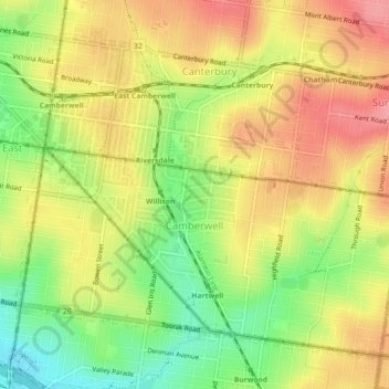
Nom : Carte topographique Camberwell, altitude, relief.
Altitude moyenne : 66 m
Altitude minimum : 14 m
Altitude maximum : 109 m
Autres cartes topographiques
Cliquez sur une carte pour visualiser sa topographie, son altitude et son relief.
Mount Dandenong
Australia > Victoria > Melbourne
Mount Dandenong has a cool oceanic climate (Cfb), with cool to mild summers and cold, damp winters. Daytime temperatures are usually 4−6 °C cooler than downtown Melbourne due to its elevation and distance from the urban heat island effect of Melbourne. It is significantly cloudier than Melbourne,…
Altitude moyenne : 395 m
Gilbertsons Grassland Nature Conservation Reserve
Australia > Victoria > Melbourne
Altitude moyenne : 36 m
Langwarrin Flora and Fauna Reserve
Australia > Victoria > Melbourne > Langwarrin
Altitude moyenne : 90 m
Narre Warren North Retarding Basin (Melbourne Water)
Australia > Victoria > Melbourne
Altitude moyenne : 76 m