
Carte topographique Hong Kong Island
Carte interactive
Cliquez sur la carte pour afficher l’altitude.
À propos de cette carte
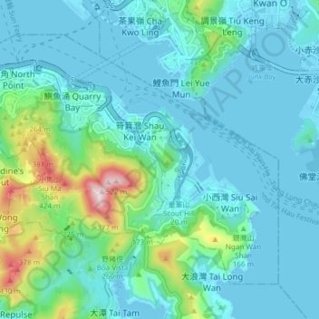
Nom : Carte topographique Hong Kong Island, altitude, relief.
Lieu : Hong Kong Island, Eastern District, Hong Kong, China (22.24572 114.18633 22.30028 114.26160)
Altitude moyenne : 84 m
Altitude minimum : -6 m
Altitude maximum : 513 m
Autres cartes topographiques
Cliquez sur une carte pour visualiser sa topographie, son altitude et son relief.
Sai Wan
China > Hong Kong > Hong Kong Island
Sai Wan, Central and Western District, Hong Kong Island, Hong Kong, China
Altitude moyenne : 81 m
Mount Davis
China > Hong Kong > Hong Kong Island
Mount Davis, Hong Kong Island, Hong Kong, China
Altitude moyenne : 71 m