
Carte topographique Yushu Tibetan Autonomous Prefecture
Carte interactive
Cliquez sur la carte pour afficher l’altitude.
À propos de cette carte
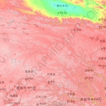
Nom : Carte topographique Yushu Tibetan Autonomous Prefecture, altitude, relief.
Lieu : Yushu Tibetan Autonomous Prefecture, Qinghai, China (31.60180 89.40222 36.28011 97.75779)
Altitude moyenne : 4 472 m
Altitude minimum : 2 678 m
Altitude maximum : 6 488 m
With elevations above 3,600 metres (12,000 ft), the prefecture has a harsh climate, with long, cold winters, and short, rainy, and cool to warm summers. Specifically, in the Köppen system, the prefecture ranges from the alpine variation of the subarctic climate (Köppen Dwc), to a full alpine climate (Köppen EH), to a semi-arid climate (Köppen BSk). Most of the annual precipitation occurs from June to September, when on average, a majority of the days each month has some rainfall. The annual mean temperature in Yushu County, at an elevation of 3,690 metres (12,110 ft), is 3.22 °C (37.8 °F) and in Qumarlêb, in the northeast of the prefecture at 4,190 m (13,750 ft) elevation, −2.13 °C (28.2 °F). Sunshine is generous, ranging from around 2500 hours in the prefecture seat to 2780 hours in Qumarlêb.
Autres cartes topographiques
Cliquez sur une carte pour visualiser sa topographie, son altitude et son relief.
Yellow River
China > Qinghai > Madoi County > Tso Kyaring
Yellow River, Tso Kyaring, Madoi County, Golog Tibetan Autonomous Prefecture, Qinghai, China
Altitude moyenne : 4 268 m