
Carte topographique Shahid Maghul
Carte interactive
Cliquez sur la carte pour afficher l’altitude.
À propos de cette carte
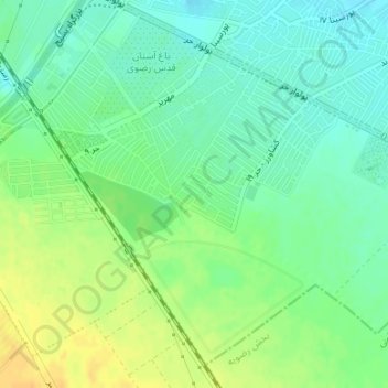
Nom : Carte topographique Shahid Maghul, altitude, relief.
Altitude moyenne : 968 m
Altitude minimum : 955 m
Altitude maximum : 984 m
Autres cartes topographiques
Cliquez sur une carte pour visualiser sa topographie, son altitude et son relief.
Quarter 1 of District 1
Iran > Razavi Khorasan Province > Mashhad
Quarter 1 of District 1, Mashhad, بخش مرکزی, Mashhad County, Razavi Khorasan Province, Iran
Altitude moyenne : 1 009 m