
Carte topographique Tillamook County
Carte interactive
Cliquez sur la carte pour afficher l’altitude.
À propos de cette carte
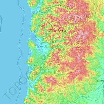
Nom : Carte topographique Tillamook County, altitude, relief.
Lieu : Tillamook County, Oregon, United States of America (45.04442 -124.09575 45.78360 -123.29927)
Altitude moyenne : 236 m
Altitude minimum : -3 m
Altitude maximum : 1 073 m
According to the U.S. Census Bureau, the county has a total area of 1,333 square miles (3,450 km2), of which 1,103 square miles (2,860 km2) is land and 230 square miles (600 km2) (17%) is water. At 3,706 feet (1130 m) in elevation, Rogers Peak is the highest point in the county and the highest in the Northern Oregon Coast Range.
Autres cartes topographiques
Cliquez sur une carte pour visualiser sa topographie, son altitude et son relief.
Cascade Range
United States of America > Oregon
Cascade Range, Wasco County, Oregon, United States of America
Altitude moyenne : 1 241 m