
Carte topographique Lorca
Carte interactive
Cliquez sur la carte pour afficher l’altitude.
À propos de cette carte
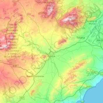
Nom : Carte topographique Lorca, altitude, relief.
Lieu : Lorca, Alto Guadalentín, Region of Murcia, Spain (37.42102 -2.01265 37.97018 -1.39668)
Altitude moyenne : 537 m
Altitude minimum : -1 m
Altitude maximum : 1 561 m
The town is situated at an elevation of 370 metres (1,200 ft) in eastern Spain between Granada and Murcia. It was part of the hura of Tidmir in the Muslim period when it became well known for its fertile soil and subsoil, and for its strategic location. It is situated on the southern slopes of the Siera del Cano mountains. The Guadalentín River flows through the town.
Autres cartes topographiques
Cliquez sur une carte pour visualiser sa topographie, son altitude et son relief.
Águilas
Spain > Region of Murcia > Alto Guadalentín
Águilas, Alto Guadalentín, Region of Murcia, Spain
Altitude moyenne : 261 m