
Carte topographique Sandford
Carte interactive
Cliquez sur la carte pour afficher l’altitude.
À propos de cette carte
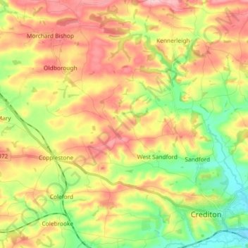
Nom : Carte topographique Sandford, altitude, relief.
Lieu : Sandford, Mid Devon, Devon, England, United Kingdom (50.79509 -3.76155 50.85097 -3.61659)
Altitude moyenne : 114 m
Altitude minimum : 36 m
Altitude maximum : 197 m
Autres cartes topographiques
Cliquez sur une carte pour visualiser sa topographie, son altitude et son relief.
Crediton
United Kingdom > England > Devon > Mid Devon
Crediton, Mid Devon, Devon, England, United Kingdom
Altitude moyenne : 71 m
Bampton
United Kingdom > England > Devon > Mid Devon
Bampton, Mid Devon, Devon, England, United Kingdom
Altitude moyenne : 185 m
Amory Park
United Kingdom > England > Devon > Mid Devon > Tiverton
Amory Park, Tiverton, Mid Devon, Devon, South West England, England, United Kingdom
Altitude moyenne : 91 m
Bailey
United Kingdom > England > Devon > Mid Devon > Newton St. Cyres > Bailey
Bailey, Newton St. Cyres, Mid Devon, Devon, South West England, England, EX5 5DF, United Kingdom
Altitude moyenne : 91 m
Bradninch
United Kingdom > England > Devon > Mid Devon
Bradninch, Mid Devon, Devon, England, United Kingdom
Altitude moyenne : 104 m