
Carte topographique Acadia National Park
Carte interactive
Cliquez sur la carte pour afficher l’altitude.
À propos de cette carte
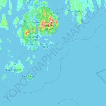
Nom : Carte topographique Acadia National Park, altitude, relief.
Altitude moyenne : 9 m
Altitude minimum : -3 m
Altitude maximum : 452 m
The ecological zones at Acadia National Park, from highest to lowest elevation, include: nearly barren mountain summits; northern boreal and eastern deciduous forests on the mountainsides; freshwater lakes and ponds, as well as wetlands like marshes and swamps in the valleys between mountains; and the Atlantic shoreline with rocky and sandy beaches, intertidal and subtidal zones.
Autres cartes topographiques
Cliquez sur une carte pour visualiser sa topographie, son altitude et son relief.
Otter Cliffs
United States > Maine > Hancock County > Bar Harbor
Otter Cliffs, Bar Harbor, Hancock County, Maine, United States
Altitude moyenne : 13 m