
Carte topographique São José do Rio Preto
Carte interactive
Cliquez sur la carte pour afficher l’altitude.
À propos de cette carte
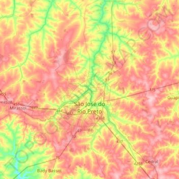
Nom : Carte topographique São José do Rio Preto, altitude, relief.
Altitude moyenne : 527 m
Altitude minimum : 430 m
Altitude maximum : 602 m
São José do Rio Preto is located in northwest of the state of São Paulo in a region between the rivers Grande, Paraná and Tietê. The ecosystem in the region lies between the Cerrado (Brazilian savanna) with traces of the Atlantic Forest. Topographycally, it is characterized by a slightly undulated relief, with a medium elevation of 489 m (1,604 ft).