
Carte topographique Poplar Creek
Carte interactive
Cliquez sur la carte pour afficher l’altitude.
À propos de cette carte
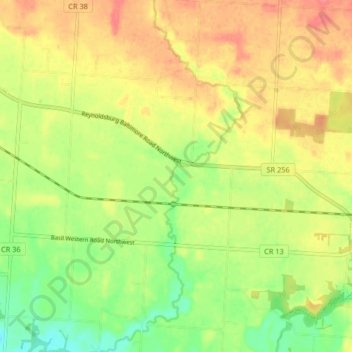
Nom : Carte topographique Poplar Creek, altitude, relief.
Lieu : Poplar Creek, Fairfield County, Ohio, 43112, United States (39.82574 -82.68223 39.88871 -82.65061)
Altitude moyenne : 268 m
Altitude minimum : 236 m
Altitude maximum : 296 m
Autres cartes topographiques
Cliquez sur une carte pour visualiser sa topographie, son altitude et son relief.
Rising Park
United States > Ohio > Fairfield County > Lancaster
Rising Park, Lancaster, Pleasant Township, Fairfield County, Ohio, United States
Altitude moyenne : 274 m
Baltimore
United States > Ohio > Fairfield County
Baltimore, Liberty Township, Fairfield County, Ohio, 43105, United States
Altitude moyenne : 267 m
Whites
United States > Ohio > Fairfield County > Lancaster > Whites
Whites, Lancaster, Fairfield County, Ohio, 43130, United States
Altitude moyenne : 262 m
Lancaster
United States > Ohio > Fairfield County > Lancaster
Lancaster, Fairfield County, Ohio, 43130, United States
Altitude moyenne : 283 m
Lockville
United States > Ohio > Fairfield County > Lockville
Lockville, Fairfield County, Ohio, 43112, United States
Altitude moyenne : 251 m