
Carte topographique Monsey
Carte interactive
Cliquez sur la carte pour afficher l’altitude.
À propos de cette carte
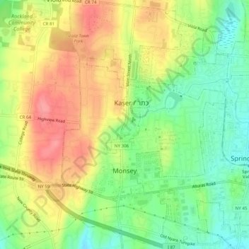
Nom : Carte topographique Monsey, altitude, relief.
Altitude moyenne : 172 m
Altitude minimum : 132 m
Altitude maximum : 214 m
Autres cartes topographiques
Cliquez sur une carte pour visualiser sa topographie, son altitude et son relief.
South Glens Falls
United States of America > New York > South Glens Falls
South Glens Falls, Moreau, Saratoga County, New York, 12803, United States of America
Altitude moyenne : 96 m
Waterburg
United States of America > New York > Waterburg
Waterburg, Ulysses Town, Tompkins County, New York, 14886, United States of America
Altitude moyenne : 318 m
Parish
United States of America > New York > Parish
Parish, Town of Parish, Oswego County, New York, 13131, United States of America
Altitude moyenne : 147 m
Walton Park
United States of America > New York > Walton Park
Walton Park, Town of Monroe, Orange County, New York, United States of America
Altitude moyenne : 216 m
New York County
United States of America > New York > New York
Manhattan, New York County, New York, United States of America
Altitude moyenne : 17 m
Peekskill
United States of America > New York > Peekskill
Peekskill, Westchester, New York, 10566, United States of America
Altitude moyenne : 67 m
Saint Lawrence
United States of America > New York
Saint Lawrence, New York, United States of America
Altitude moyenne : 239 m
Allegany County
United States of America > New York
Allegany County, New York, United States of America
Altitude moyenne : 561 m