Géolocaliser

Carte topographique Thrapston

Cliquez sur la carte pour afficher l’altitude.

À propos de cette carte

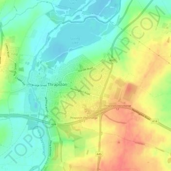
Nom : Carte topographique Thrapston, altitude, relief.

Lieu : Thrapston, North Northamptonshire, England, United Kingdom (52.38359 -0.54611 52.40966 -0.49283)

Altitude moyenne : 47 m

Altitude minimum : 23 m

Altitude maximum : 77 m

Autres cartes topographiques

Cliquez sur une carte pour visualiser sa topographie, son altitude et son relief.

Laxton

United Kingdom > England > North Northamptonshire

Altitude moyenne : 86 m

Dingley

United Kingdom > England > North Northamptonshire

Altitude moyenne : 110 m

Lowick

United Kingdom > England > North Northamptonshire

Altitude moyenne : 57 m

Corby

United Kingdom > England > North Northamptonshire

Altitude moyenne : 103 m

Pipewell

United Kingdom > England > North Northamptonshire

Altitude moyenne : 124 m

Rushton

United Kingdom > England > North Northamptonshire

Altitude moyenne : 112 m

Slade

United Kingdom > England > North Northamptonshire > Orton

Altitude moyenne : 123 m

Corby

United Kingdom > England > North Northamptonshire

Altitude moyenne : 103 m

Équipez-vous pour votre prochaine aventure :

🍳Ensemble de cuisine de camping - Casseroles et poêles compactes pour le bivouac
🪢Cordes paracorde - Cordes polyvalentes pour camping et survie
🥾Chaussures de marche - Chaussures légères et confortables pour sentiers et balades
🔥Réchaud de camping ultra-léger - Pour cuisiner rapidement après une longue ascension
🎒Housse de pluie pour sac à dos - Protection supplémentaire pour garder votre contenu au sec

En tant que Partenaire Amazon, ce site perçoit une commission sur les achats éligibles sans surcoût pour vous.