
Carte topographique Ma'anshan
Carte interactive
Cliquez sur la carte pour afficher l’altitude.
À propos de cette carte
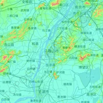
Nom : Carte topographique Ma'anshan, altitude, relief.
Lieu : Ma'anshan, Anhui, China (31.29207 117.89459 32.06126 118.88248)
Altitude moyenne : 23 m
Altitude minimum : -2 m
Altitude maximum : 454 m
Autres cartes topographiques
Cliquez sur une carte pour visualiser sa topographie, son altitude et son relief.
Songtuan
China > Anhui > Lieshan District
Songtuan, Lieshan District, Huaibei, Anhui, China
Altitude moyenne : 41 m
Huangshan
China > Anhui > Huangshan City
Huangshan, Huangshan City, Huangshan District, Anhui, 242700, China
Altitude moyenne : 906 m
Xuancheng City
China > Anhui > Xuancheng City
Xuancheng City, Xuanzhou District, Anhui, China
Altitude moyenne : 226 m