
Carte topographique Kisoro
Carte interactive
Cliquez sur la carte pour afficher l’altitude.
Kisoro
Kisoro is approximately 76 kilometres (47 mi), by road, west of Kabale, the largest city in the Kigezi sub-region.[2] This is approximately 484 kilometres (301 mi), by road, southwest of Kampala, the capital of Uganda and the country's largest city.[3] Kisoro is east of Rumangabo and the Virunga Mountains in the Democratic Republic of the Congo (DRC). The geographical coordinates of Kisoro are 1°17'06.0"S, 29°41'06.0"E (Latitude:-1.2850; Longitude:29.6850).[4] Kisoro Town Council sits at an average elevation of 1,929 metres (6,329 ft), above mean sea level.[5]
À propos de cette carte
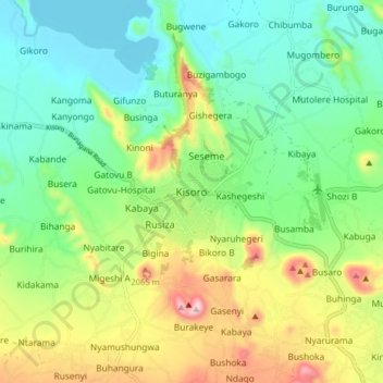
Nom : Carte topographique Kisoro, altitude, relief.
Lieu : Kisoro, Cyanika, Kisoro, Western Region, Uganda (-1.32221 29.65267 -1.24221 29.73267)
Altitude moyenne : 1 911 m
Altitude minimum : 1 781 m
Altitude maximum : 2 170 m