
Carte topographique Maitai Dam
Carte interactive
Cliquez sur la carte pour afficher l’altitude.
À propos de cette carte
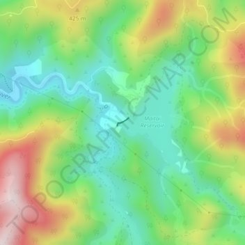
Nom : Carte topographique Maitai Dam, altitude, relief.
Lieu : Maitai Dam, Nelson, New Zealand (-41.29434 173.36982 -41.29346 173.37144)
Altitude moyenne : 293 m
Altitude minimum : 102 m
Altitude maximum : 615 m
Autres cartes topographiques
Cliquez sur une carte pour visualiser sa topographie, son altitude et son relief.
Dew Lakes
New Zealand > Nelson > Nelson
Dew Lakes, Saddle Hill Route, Nelson, New Zealand
Altitude moyenne : 800 m
Wakapuaka River
New Zealand > Nelson > Nelson
Wakapuaka River, Nelson, 7071, New Zealand
Altitude moyenne : 164 m
Whangamoa River
New Zealand > Nelson > Nelson
Whangamoa River, Nelson, New Zealand
Altitude moyenne : 225 m