
Carte topographique Schliprüthen
Carte interactive
Cliquez sur la carte pour afficher l’altitude.
À propos de cette carte
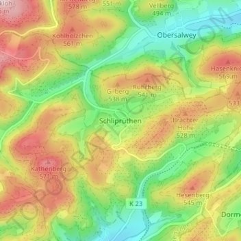
Nom : Carte topographique Schliprüthen, altitude, relief.
Altitude moyenne : 472 m
Altitude minimum : 348 m
Altitude maximum : 619 m
Autres cartes topographiques
Cliquez sur une carte pour visualiser sa topographie, son altitude et son relief.
Rührberg
Duitsland > Noordrijn-Westfalen > Kreis Olpe > Finnentrop
Rührberg, Finnentrop, Kreis Olpe, Noordrijn-Westfalen, Duitsland
Altitude moyenne : 458 m