
Carte topographique Sognefjorden
Carte interactive
Cliquez sur la carte pour afficher l’altitude.
À propos de cette carte
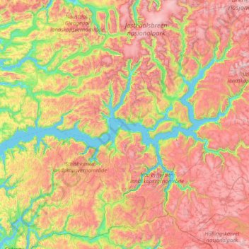
Nom : Carte topographique Sognefjorden, altitude, relief.
Lieu : Sognefjorden, 6848, Norway (61.02276 5.20707 61.49474 7.71272)
Altitude moyenne : 806 m
Altitude minimum : -1 m
Altitude maximum : 2 116 m
The inner end of the Sognefjord is southeast of a mountain range rising to about 2,000 metres (6,600 ft) above sea level and covered by the Jostedalsbreen, continental Europe's largest glacier. Thus the climate of the inner end of Sognefjorden and its branches are not as wet as on the outer coastline. Hurrungane range at the eastern end of the fjord reaches 2,400 metres (7,900 ft). The greatest elevation from seabed to summit is at Sogndal. Several rivers pour fresh water into the fjord with an annual "spring" flood in June. The mouth of the fjord is surrounded by many islands including Sula, Losna, and Hiserøyna. The Sognefjord cuts through a northwestern gneiss area with a south-west to north-east structure, and penetrates the Caledonian fold through in the inner part. There is no clear relation between the east–west direction of the main fjord and the fold patterns of the bedrock, while some of tributary fjords in the parts corresponds to fold pattern.
Autres cartes topographiques
Cliquez sur une carte pour visualiser sa topographie, son altitude et son relief.
Midsund
Midsund, Molde, Møre og Romsdal, 6475, Norway
Altitude moyenne : 114 m
Havøysund - Ávanuorri
Havøysund - Ávanuorri, Måsøy, Troms og Finnmark, 9690, Norway
Altitude moyenne : 70 m
Rauland
Rauland, Vinje, Vestfold og Telemark, Norway
Altitude moyenne : 761 m
Dyrstad
Dyrstad, Ibestad, Troms og Finnmark, 9450, Norway
Altitude moyenne : 62 m
Rotsund - Guohcanuorri - Nuora
Rotsund - Guohcanuorri - Nuora, Nordreisa, Troms og Finnmark, Norway
Altitude moyenne : 189 m
Bjørnevatn
Bjørnevatn, South Varanki, Troms og Finnmark, 9910, Norway
Altitude moyenne : 82 m
Vinje
Norway > Møre og Romsdal > Geiranger
Vinje, Geiranger, Stranda, Møre og Romsdal, 6216, Norway
Altitude moyenne : 562 m
Bloomberg
Bloomberg, Stranda, Møre og Romsdal, Norway
Altitude moyenne : 327 m
Vinjane
Norway > Vestland > Aurlandsvangen
Vinjane, Aurlandsvangen, Aurland, Vestland, 5745, Norway
Altitude moyenne : 231 m
Vesle Vålåsjå
Vesle Vålåsjå, Tinn, Vestfold og Telemark, Norway
Altitude moyenne : 1 170 m
Raudnesvika naturreservat
Raudnesvika naturreservat, Sula, Møre og Romsdal, Norway
Altitude moyenne : 186 m