Géolocaliser

Carte topographique Rubín

Cliquez sur la carte pour afficher l’altitude.

À propos de cette carte

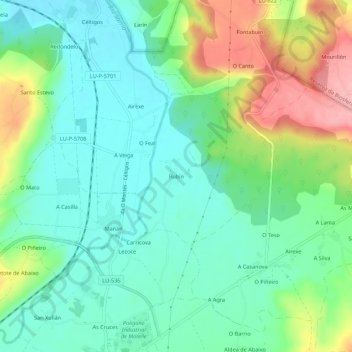
Nom : Carte topographique Rubín, altitude, relief.

Lieu : Rubín, Sarria, Lugo, Galicia, 27614, España (42.79584 -7.39547 42.83584 -7.35547)

Altitude moyenne : 430 m

Altitude minimum : 387 m

Altitude maximum : 521 m

Autres cartes topographiques

Cliquez sur une carte pour visualiser sa topographie, son altitude et son relief.

Chorente

España > Galicia > Sarria > Sarria

Altitude moyenne : 626 m

Vilamaior

España > Galicia > Sarria > Sarria

Altitude moyenne : 623 m

Fontao

España > Galicia > Sarria > Sarria

Altitude moyenne : 460 m

Barbadelo

España > Galicia > Sarria > Sarria

Altitude moyenne : 576 m

Ortoá

España > Galicia > Sarria > Sarria

Altitude moyenne : 614 m

Louseiro

España > Galicia > Sarria > Sarria

Altitude moyenne : 507 m

Santo André de Paradela

España > Galicia > Sarria > Sarria

Altitude moyenne : 578 m

Équipez-vous pour votre prochaine aventure :

🔦Mini lampe LED porte-clés - Éclairage d'appoint toujours à portée de main
🧼Savon de camping biodégradable - Respectez l'environnement lors de vos expéditions
🔪Couteaux de camping - Couteaux polyvalents pour outdoor
🔭Jumelles de randonnée compactes - Pour observer les sommets et la faune à distance
🦟Répulsifs anti-moustiques - Protection contre insectes

En tant que Partenaire Amazon, ce site perçoit une commission sur les achats éligibles sans surcoût pour vous.