
Carte topographique Murang'a
Carte interactive
Cliquez sur la carte pour afficher l’altitude.
À propos de cette carte
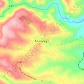
Nom : Carte topographique Murang'a, altitude, relief.
Lieu : Murang'a, Kiharu, Murang'a County, Central Kenya, 10200, Kenya (-0.73750 37.13963 -0.71061 37.17323)
Altitude moyenne : 1 286 m
Altitude minimum : 1 161 m
Altitude maximum : 1 387 m
The town is low, a bit hilly, small but picturesque with an altitude of 4120 ft (1255 metres) above sea level. As a result of the varying altitudes, Murang'a can get quite cold from May to mid-August, and can experience hail. To the west of the town can be seen the rolling Kikuyu farmlands that extend as far as the eyes can see.