
Faire un don
Équipez-vous pour votre prochaine aventure :
En tant que Partenaire Amazon, ce site perçoit une commission sur les achats éligibles sans surcoût pour vous.
Carte topographique Ashoknagar Kalyangarh
Cliquez sur la carte pour afficher l’altitude.
Faire un don
Équipez-vous pour votre prochaine aventure :
En tant que Partenaire Amazon, ce site perçoit une commission sur les achats éligibles sans surcoût pour vous.
Ashoknagar Kalyangarh
Ashokenagar is located at 22°49′59″N 88°37′59″E / 22.833°N 88.633°E / 22.833; 88.633. It is situated in the World's largest delta, The Ganga-Brahmaputra Delta. The elevation of Ashokenagar Kalyangarh from sea-level is 8 meters. There are many forest, several lakes, some canals and vast green fields in this area. Below the ground of Ashokenagar, there is a huge amount of petroleum (as the ONGC and The Union Minister of Petroleum and Natural Gas, Mr. Dharmendra Pradhan said).
Faire un don
Équipez-vous pour votre prochaine aventure :
En tant que Partenaire Amazon, ce site perçoit une commission sur les achats éligibles sans surcoût pour vous.
À propos de cette carte
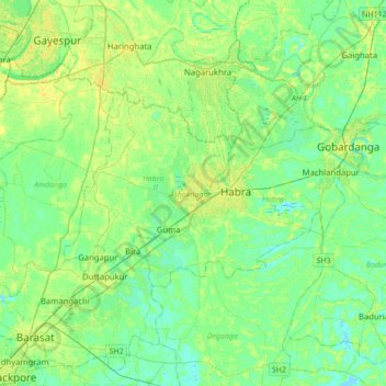
Nom : Carte topographique Ashoknagar Kalyangarh, altitude, relief.
Altitude moyenne : 7 m
Altitude minimum : -2 m
Altitude maximum : 17 m
Faire un don
Équipez-vous pour votre prochaine aventure :
En tant que Partenaire Amazon, ce site perçoit une commission sur les achats éligibles sans surcoût pour vous.