
Faire un don
Équipez-vous pour votre prochaine aventure :
En tant que Partenaire Amazon, ce site perçoit une commission sur les achats éligibles sans surcoût pour vous.
Carte topographique Wooton
Cliquez sur la carte pour afficher l’altitude.
Faire un don
Équipez-vous pour votre prochaine aventure :
En tant que Partenaire Amazon, ce site perçoit une commission sur les achats éligibles sans surcoût pour vous.
À propos de cette carte
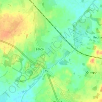
Nom : Carte topographique Wooton, altitude, relief.
Altitude moyenne : 90 m
Altitude minimum : 75 m
Altitude maximum : 112 m
Faire un don
Équipez-vous pour votre prochaine aventure :
En tant que Partenaire Amazon, ce site perçoit une commission sur les achats éligibles sans surcoût pour vous.
Autres cartes topographiques
Cliquez sur une carte pour visualiser sa topographie, son altitude et son relief.
Ludlow
United Kingdom > England > Shropshire
During the 12th century, the planned town of Ludlow was formed, in stages, the town providing a useful source of income for successive Marcher Lords, based on rents, fines, and tolls. They developed the town on a regular grid pattern, although this was adapted somewhat to match the local topography, from the…
Altitude moyenne : 108 m
Shrewsbury
United Kingdom > England > Shropshire
The town centre is partially built on a hill whose elevation is, at its highest, 246 feet (75 m) above sea level. The longest river in the United Kingdom, the River Severn, flows through the town, forming a meander around its centre. The Rea Brook is a small river that has its confluence with the Severn at…
Altitude moyenne : 69 m