
Carte topographique Folsom
Carte interactive
Cliquez sur la carte pour afficher l’altitude.
À propos de cette carte
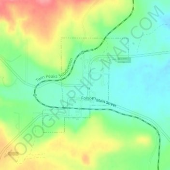
Nom : Carte topographique Folsom, altitude, relief.
Lieu : Folsom, Union County, New Mexico, United States (36.83959 -103.92685 36.85459 -103.90980)
Altitude moyenne : 1 970 m
Altitude minimum : 1 938 m
Altitude maximum : 2 020 m
Folsom is situated in a wide valley near the headwaters of the Cimarron River, locally known as the Dry Cimarron, as it runs underground during part of its course through eastern New Mexico. The village is ringed by buttes, mesas, and old volcanic cones and lava flows. Most of the valley is rich grassland, with a pinyon pine and juniper forest found on slopes and in rocky areas. Ponderosa pines are found in canyons and at higher elevations. Large ranches and cattle grazing are typical of the area, although some irrigated agriculture is found downstream from Folsom. Hunting for deer, bear, elk, pronghorn, and turkey is popular on local ranches.
Autres cartes topographiques
Cliquez sur une carte pour visualiser sa topographie, son altitude et son relief.
Clayton
United States > New Mexico > Union County
Clayton, Union County, New Mexico, United States
Altitude moyenne : 1 526 m
Des Moines
United States > New Mexico > Union County
Des Moines, Union County, New Mexico, 88418, United States
Altitude moyenne : 2 024 m