
Carte topographique Liangshan
Carte interactive
Cliquez sur la carte pour afficher l’altitude.
À propos de cette carte
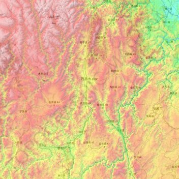
Nom : Carte topographique Liangshan, altitude, relief.
Lieu : Liangshan, Sichuan, China (26.04817 100.16675 29.30510 103.87517)
Altitude moyenne : 2 439 m
Altitude minimum : 312 m
Altitude maximum : 5 740 m
Owing to its low latitude and high elevation, Liangshan has a mild climate. Under the Köppen system, the prefecture belongs to the humid subtropical zone (Köppen Cwa). Winters feature mild days and cool nights, while summers are very warm and humid. Monthly daily mean temperatures range from 9.6 °C (49.3 °F) in January to 22.3 °C (72.1 °F) in July. Unlike much of the province, which lies in the Sichuan Basin, humidity levels in winter are rather low, but like the rest of the province, rainfall is concentrated in the months of June through September, and the prefecture is virtually rainless in winter.
Autres cartes topographiques
Cliquez sur une carte pour visualiser sa topographie, son altitude et son relief.
Xichang City
Xichang City, Liangshan, Sichuan, 615000, China
Altitude moyenne : 2 319 m
Mount Gongga
China > Sichuan > Luding County
Mount Gongga, Luding County, Kardze Tibetan Autonomous Prefecture, Sichuan, China
Altitude moyenne : 6 496 m
Mengzhuiwan
China > Sichuan > Chenghua District > Mengzhuiwan
Mengzhuiwan, Chenghua District, Chengdu City, Sichuan, 610054, China
Altitude moyenne : 502 m