
Carte topographique Drominahilla
Carte interactive
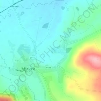
Cliquez sur la carte pour afficher l’altitude.
À propos de cette carte
Nom : Carte topographique Drominahilla, altitude, relief.
Altitude moyenne : 127 m
Altitude minimum : 90 m
Altitude maximum : 237 m
Autres cartes topographiques
Cliquez sur une carte pour visualiser sa topographie, son altitude et son relief.
Kilnamartery
Ireland > County Cork > Municipal District of Macroom
Kilnamartery, Municipal District of Macroom, County Cork, Munster, Ireland
Altitude moyenne : 118 m
Iniscarra Dam View
Ireland > County Cork > Municipal District of Macroom
Iniscarra Dam View, L5228, Ovens, Municipal District of Macroom, County Cork, Munster, P31 TX39, Ireland
Altitude moyenne : 83 m
Monallig
Ireland > County Cork > Municipal District of Macroom
Monallig, Cannaway ED, Municipal District of Macroom, County Cork, Munster, Ireland
Altitude moyenne : 90 m
Macroom
Ireland > County Cork > Municipal District of Macroom
Macroom, Municipal District of Macroom, County Cork, Munster, Ireland
Altitude moyenne : 210 m
Loughane East
Ireland > County Cork > Municipal District of Macroom
Loughane East, Matehy, Municipal District of Macroom, County Cork, Munster, Ireland
Altitude moyenne : 98 m
Donoughmore
Ireland > County Cork > Municipal District of Macroom
Donoughmore, Municipal District of Macroom, County Cork, Munster, Ireland
Altitude moyenne : 183 m