
Carte topographique Rochester Hills
Carte interactive
Cliquez sur la carte pour afficher l’altitude.
À propos de cette carte
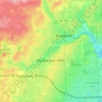
Nom : Carte topographique Rochester Hills, altitude, relief.
Lieu : Rochester Hills, Oakland County, Michigan, United States (42.62100 -83.21378 42.71249 -83.09144)
Altitude moyenne : 250 m
Altitude minimum : 200 m
Altitude maximum : 318 m
Rochester Hills is bordered to the north by Oakland Charter Township along Dutton Road, to the south by the city of Troy along South Boulevard, to the east by Shelby Township in Macomb County along Dequindre Road, and to the west by the city of Auburn Hills along part of Adams Road. Rochester Hills is also partially bordered by the city of Rochester to the east. Elevations in the city range from 690 feet (210 m) above sea level in the southeastern portion of the city to 1,032 feet (315 m) in the northwestern section.
Autres cartes topographiques
Cliquez sur une carte pour visualiser sa topographie, son altitude et son relief.
Farmington Hills
United States > Michigan > Oakland County
Farmington Hills, Oakland County, Michigan, United States
Altitude moyenne : 246 m
Lake Orion
United States > Michigan > Oakland County
Lake Orion, Oakland County, Michigan, 48362, United States
Altitude moyenne : 303 m
Highland Charter Township
United States > Michigan > Oakland County
Highland Charter Township, Oakland County, Michigan, United States
Altitude moyenne : 314 m
Independence Charter Township
United States > Michigan > Oakland County
Independence Charter Township, Oakland County, Michigan, United States
Altitude moyenne : 318 m
Troy
United States > Michigan > Oakland County
Troy, Oakland County, Michigan, United States
Altitude moyenne : 221 m
Southfield
United States > Michigan > Oakland County
Southfield, Oakland County, Michigan, United States
Altitude moyenne : 210 m
Novi
United States > Michigan > Oakland County
Novi, Oakland County, Michigan, United States
Altitude moyenne : 280 m
Huron Heights
United States > Michigan > Oakland County > Waterford Charter Township
Huron Heights, Waterford Charter Township, Oakland County, Michigan, 48328, United States
Altitude moyenne : 292 m
Oxford Charter Township
United States > Michigan > Oakland County
Oxford Charter Township, Oakland County, Michigan, 48371, United States
Altitude moyenne : 325 m
Springfield Charter Township
United States > Michigan > Oakland County
Springfield Charter Township, Oakland County, Michigan, 48350, United States
Altitude moyenne : 318 m
Keego Harbor
United States > Michigan > Oakland County
Keego Harbor, Oakland County, Michigan, United States
Altitude moyenne : 286 m
Bloomfield
United States > Michigan > Oakland County > Birmingham
Bloomfield, Birmingham, Oakland County, Michigan, 35075, United States
Altitude moyenne : 231 m
Bloomfield Township
United States > Michigan > Oakland County
Bloomfield Township, Oakland County, Michigan, United States
Altitude moyenne : 269 m
Union Lake
United States > Michigan > Oakland County > White Lake Charter Township
Union Lake, White Lake Charter Township, Oakland County, Michigan, 48386, United States
Altitude moyenne : 290 m
Birmingham
United States > Michigan > Oakland County
Birmingham, Oakland County, Michigan, United States
Altitude moyenne : 234 m
Davisburg
United States > Michigan > Oakland County
Davisburg, Oakland County, Michigan, 48350, United States
Altitude moyenne : 309 m
Commerce Township
United States > Michigan > Oakland County
Commerce Township, Oakland County, Michigan, 48382, United States
Altitude moyenne : 286 m
West Bloomfield Charter Township
United States > Michigan > Oakland County
West Bloomfield Charter Township, Oakland County, Michigan, United States
Altitude moyenne : 286 m
Village of Clarkston
United States > Michigan > Oakland County
Village of Clarkston, Oakland County, Michigan, United States
Altitude moyenne : 308 m
Ortonville State Recreation Area
United States > Michigan > Oakland County
Ortonville State Recreation Area, Hadley Township, Oakland County, Michigan, United States
Altitude moyenne : 305 m
Clawson
United States > Michigan > Oakland County
Clawson, Oakland County, Michigan, 48017, United States
Altitude moyenne : 206 m
Milford Township
United States > Michigan > Oakland County
Milford Township, Oakland County, Michigan, United States
Altitude moyenne : 296 m
Rochester
United States > Michigan > Oakland County > Rochester
Rochester, Oakland County, Michigan, United States
Altitude moyenne : 242 m
Lyon Township
United States > Michigan > Oakland County
Lyon Township, Oakland County, Michigan, 48165, United States
Altitude moyenne : 291 m
Rochester Hills
United States > Michigan > Oakland County > Rochester Hills
Rochester Hills, Oakland County, Michigan, 48309, United States
Altitude moyenne : 246 m
Auburn Hills
United States > Michigan > Oakland County
Auburn Hills, Oakland County, Michigan, 48326, United States
Altitude moyenne : 284 m
Berkley
United States > Michigan > Oakland County > Berkley
Berkley, Oakland County, Michigan, United States
Altitude moyenne : 210 m
Waterford Township
United States > Michigan > Oakland County > Waterford Township
Waterford Township, Oakland County, Michigan, United States
Altitude moyenne : 294 m
Troy
United States > Michigan > Oakland County > Troy
Troy, Oakland County, Michigan, 48085:48098, United States
Altitude moyenne : 229 m
Beverly Hills
United States > Michigan > Oakland County > Beverly Hills
Beverly Hills, Southfield Township, Oakland County, Michigan, United States
Altitude moyenne : 224 m
Royal Oak
United States > Michigan > Oakland County > Royal Oak
Royal Oak, Oakland County, Michigan, United States
Altitude moyenne : 203 m
Pontiac
United States > Michigan > Oakland County > Pontiac
Pontiac, Oakland County, Michigan, United States
Altitude moyenne : 290 m
Oakland Charter Township
United States > Michigan > Oakland County
Oakland Charter Township, Oakland County, Michigan, United States
Altitude moyenne : 284 m